|
|
|
|
|
|
by rapjr9
244 days ago
|
|
|
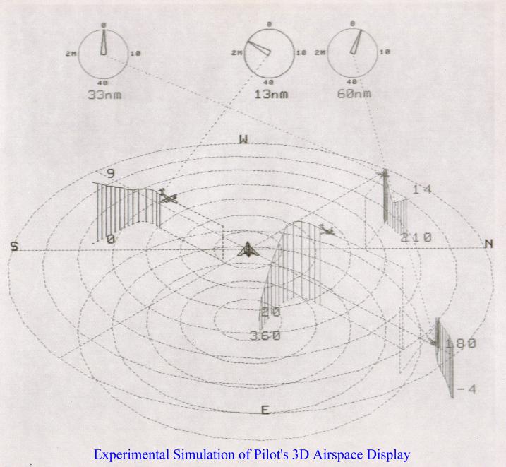
Cool, I tried something similar 30 years ago working for a military contractor: http://zoom.interoscitor.com/PetersonEnterprises/Consulting/... I was asked to come up with a 3D display of the airspace around an aircraft for the pilot to use and which could replace the 2D displays used then. People were impressed, but decided it was impractical for a variety of reasons. You can't really tell where the aircraft are relative to each other and the ground without rotating the display (which means the pilot loses their orientation), and there are no altitude indicators and it's difficult to tell where each aircraft is relative to the others. (Which is why I added the vertical lines and ground tracks.) Also things get visually messy when several aircraft are close together, even if you use different colors (which doesn't work for the colorblind). For example, could you use this display to tell if a collision is imminent near ground level in proximity to an airport? The display does give you a high level sense of what is going on in the airspace; it may not have enough details to be of practical use to pilots and air traffic controllers. I'd suggest consulting with them to get feedback. Maybe this would be practical as a VR display? How did they solve this in the F-35 helmet display? |
|
|