Hacker News new | ask | show | jobs
by skzv 1375 days ago
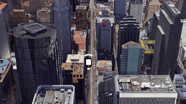
Google explores these techniques as well. They're critical to improving accuracy in urban areas where you don't have line of sight to satellites (this is why your GNSS (AKA GPS) location is terrible whenever you're in a city). Here's [0] a cool gif visualizing the principle of GNSS ray tracing taken from one of Google's blog posts [1]. Here's an article with more information about Google's techniques [2].

[0] https://1.bp.blogspot.com/-FskvGHx-IOc/X8qtZi1GUNI/AAAAAAAAP...

[1] https://android-developers.googleblog.com/2020/12/improving-...

[2] https://insidegnss.com/end-game-for-urban-gnss-googles-use-o...

3 comments

That seems much more useful, since it applies to all Android apps, whereas Uber's solution would be limited to their app only.
Almost like they wrote a blog article about it so others could learn from it.

If it were available to all android apps I don't know why Uber would go out of their way to reimplement it. So it must not be available to all apps and exclusive to Google maps and Waze

Uber's post is actually two years older than the Google one.
> April 19, 2018 / Global

Yes, original post needs a (2018) in the title.

What a brilliant use of all that satellite imagery.
I think it says that FLP (Fused Location Provider) is not built in to Android.
FLP is an SDK available on Android devices with Google Play Services (https://developer.android.com/training/location/request-upda...). According to the blog post, it should theoretically be rolled out to any phone with Android 8 or later.

The Uber blog post is from 2018, and Google's implementation came in 2020.

I tried to enter "now" and the stupid phone decided I was going for "not".