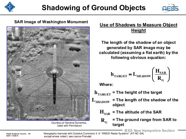
| You have the right idea. It can also help to think of it as a projection problem. The image is displayed as if it were taken from a camera directly above the ground, but the radar is actually located at some other location. In order to create the image an assumption is made that everything is located at the same height. So when something like a skyscraper is actually hundreds of meters above the ground, the radar detections from that object are projected to the wrong location in the image. The term to look up is "foreshortening". This is similar to (but not exactly) what happens when aerial photography is used to make maps. Building in Google Maps get flattened and the roofs are translated to someplace other than where they should be. What also helps is to look for "shadows" in the SAR imagery. The shadow tells you where the radar is located. From that you can intuit what side of objects the radar is actually seeing. A great example used in textbooks is this image of the Washington Monument. You can tell from the shadow that the radar is located to the north^. So even though it looks like you're seeing the south side of the monument, the image is actually showing the north side. The north face of the monument has been projected onto the ground in the direction of the radar.
http://image.slidesharecdn.com/radar-2009-a18-synthetic-aper... So looking at the Tokyo image again. The tree shadows are south of the trees, so the radar is located to the north. The tops of the skyscrapers are closer to the radar than the bottoms, so the tops of the skyscrapers will be shifted to the north towards the radar. However, because the radar is located to the north, what we see is actually the north side of the skyscrapers. The false perspective makes it seem like we should be seeing the south side of the skyscrapers, but that's an illusion. ^ I'm just assuming that "up" is north. |