|
|
|
|
|
|
by throwanem
3265 days ago
|
|
|
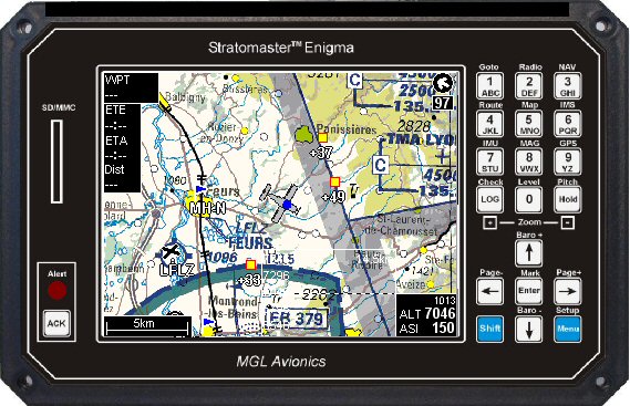
No, they don't already do this. As 'phdp already explained, there are no instrument landing systems installed in the US which include GPS augmentation. So, while the moving map will show the same position information as at any other time when the aircraft's GPS receiver has sufficient signal, it's going to look something like this: http://www.stratomaster.eu/lignes/mgl/photos/enscr4.jpg Meanwhile, the ICAO approach plate for SFO's runway 28R looks like this: http://redwoodva.net/lib/skins/en/images/events/charts/ksfo_... - trivially simple to comprehend at a glance, I am sure you will agree! As far as "stupid mistake" goes, you sure do seem quick to judge professionals in a highly technical field totally unrelated to your own, and of which you've made clear you are happy to preserve your ignorance. Were I you, I'd hope my own errors meet with a greater extent of charity than that precious little you see fit to mete out. But that's your problem, not mine. Good luck with it. |
|
|
The heck? Everyone makes stupid mistakes. Hell, I make more of them than a lot of people I know. That's why there are procedures and checklists and redundancies and automated systems -- to prevent stupid mistakes, evne by the best people. Where was I ever judging the pilot for heaven's sake?! Maybe you could be a little more charitable with how you judge people?